Google Earth Free 4.2 Build 0205 for Windows
Google Earth combina la potenza delle funzioni di ricerca di Google con immagini satellitari, mappe, rilievi ed edifici in 3D per portare sulla tua scrivania le informazioni geografiche di tutto il mondo.
Vola verso casa tua. Digita semplicemente un indirizzo, premi Cerca e lo raggiungerai istantaneamente nel visualizzatore 3D.
Cerca scuole, parchi, ristoranti e hotel. Ottieni indicazioni stradali.
Inclina e ruota la vista per visualizzare terreno ed edifici 3D o alza lo sguardo per esplorare il cielo
Salva e condividi le tue ricerche e i tuoi elementi Preferiti.
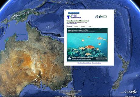
Fin dal lancio di Google Earth, gli utenti hanno esplorato il mondo e creato sovrapposizioni di contenuti (file KML) per condividere le proprie esplorazioni con gli altri. Al momento, stiamo pubblicando i file KML creati dagli utenti ogni settimana nella nuova Galleria di Google Earth.
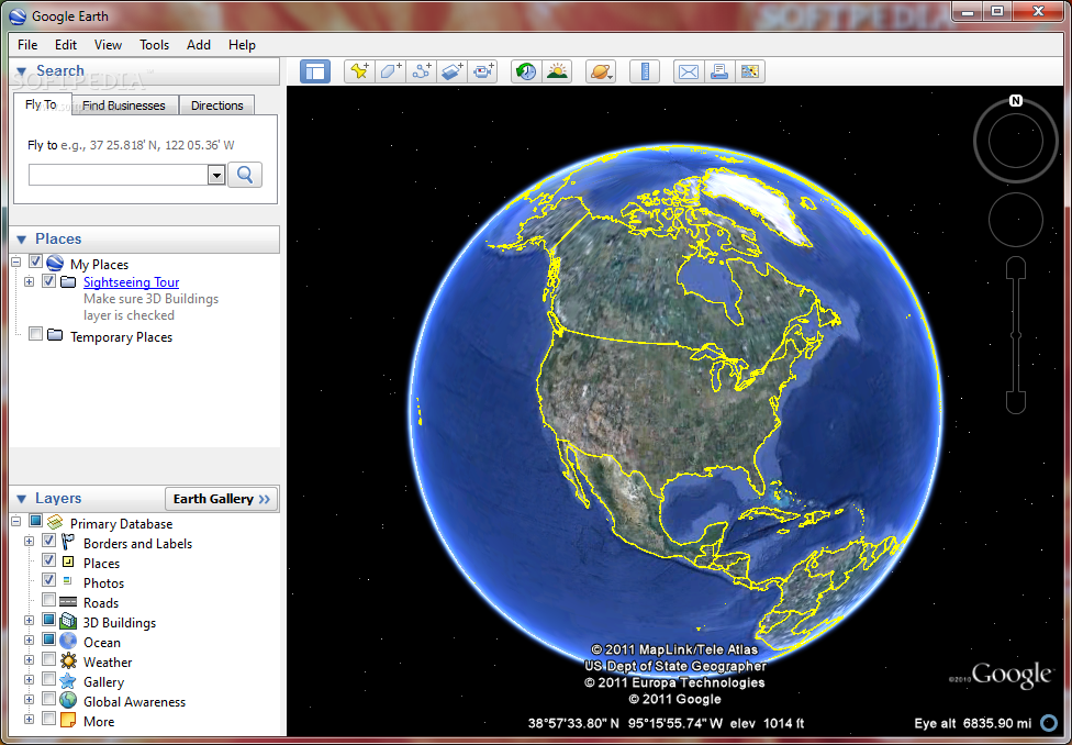
Google Earth combines satellite imagery, maps and the power of Google Search to put the world’s geographic information at your fingertips. Fly from space to your neighborhood. Type in an address and zoom right in. Search for schools, parks, restaurants, and hotels. Get driving directions. Tilt and rotate the view to see 3D terrain and buildings. Save and share your searches and favorites. Even add your own annotations.
Google Earth lets you do smooth sailing flybyes of the entire Earth. You can easily fly to any spot on the globe, by entering any associated data, like street addresses, place names or lat/long coordinates. There are overlays that put additional information on the map, like roads, international boundaries, terrain, 3D buildings, crime statistics, schools, stadiums, any number of interesting stuff. You can do Local searches in the program, with icons on the map and a display on the side showing your results.
You can leave notes, called "placemarks" all over the map, so you can remember where all sorts of places are. Searches and placemarks can be saved as bookmarks in "My Places". Everything can be output in an XML format called KML, that will allow the vast popularity of Google Maps to continue in Earth. You can also email a JPEG of the map, or send a KMZ file if you know the recipient has Earth installed.
Features:
- Sophisticated streaming technology delivers the data to you as you need it.
- Imagery and 3D data depict the entire earth - Terabytes of aerial and satellite imagery depict cities around the world in high-resolution detail.
- Local search lets you search for restaurants, hotels, and even driving directions. Results show in your 3D earth view. Easy to layer multiple searches, save results to folders, and share with others.
- Layers show parks, schools, hospitals, airports, retail, and more.
- Overlays – import site plans, design sketches and even scanned blueprints.
- Annotate the view with lines and polygons.
- Spreadsheet import - ingest up to 2,500 locations by address or lat/lon.
- KML – data exchange format let your share useful annotations.
Use it for:
- Planning a trip
- Getting driving directions
- Finding a house or apartment
- Finding a local business
- Exploring the world
Recommended configuration:
- Operating system: Windows 2000/ XP/ Vista
- CPU speed: Intel® Pentium® P4 2.4GHz+ or AMD 2400xp+
- System memory (RAM): 512MB
- 2GB hard-disk space
- 3D graphics card: 3D-capable video card with 32MB VRAM or greater
- 1280x1024, 32-bit true color screen
- Network speed: 128 kbps ("Broadband/Cable Internet")
* Google Earth Plus is an optional upgrade adding GPS device support, the ability to import spreadsheets, drawing tools and better printing.
* Google Earth Pro - for professional and commercial uses, Google Earth Pro is the ultimate research, presentation and collaboration tool for location information.
Homepage - http://earth.google.com/
Size: 12.7 MB